Showing posts with label pictographs. Show all posts

Wednesday, July 6, 2016

Fremont Indian State Park, Utah - Camping, Hiking, and Biking

Roger and I discovered a hidden gem in the Utah State Park system over the 4th of July weekend.  We were looking for a camping and hiking trip that wasn't too far from Salt Lake City and wouldn't be too overcrowded on a holiday weekend.  We also wanted a location where we could watch some fireworks on Monday evening.  After a lot of searching, Fremont Indian State Park seemed to fit the bill.  We left Salt Lake City on Saturday morning, passed through Richfield a few hours later, and made our way over to Fremont Indian State Park.

Clear Creek running through Fremont Indian State Park

We stayed in the Castle Rock campground, a two mile drive from the park's visitor center, at the end of a gravel road.  The campground was beautiful and well maintained, and many of the sites were surround by trees and spectacular views of the surrounding rock formations.  It seemed like an oasis on the desert with Joe Lott Creek running through the center of the campground.  Our site was large, but a bit exposed, and it felt more like a parking lot.  We found a more secluded area for our tent and set it up just before a strong thunderstorm moved through.  The rain and hail came down hard for several minutes, and the air was filled with the smell of pine as needles were ripped from the surrounding trees.  After hunkering down in our tent for almost an hour, I emerged to find the ground covered in ice and fog shrouding our campground.

Hail
Our tent surrounded by hail at Fremont Indian State Park

Thankfully, the sun came out and quickly warmed the air, giving us a chance to hike around the campground and explore the castle-like rocks.  Later that evening, we joined a "scorpion walk" hosted by the state park.  After listening to a talk about scorpions in the Utah desert, we were given blacklights to look for the arachnids on a nearby hill.  Scorpions fluoresce under blacklights due to chemicals in their cuticle.  We saw several small scorpions before heading back to camp and calling it a day.

Castle Rock campground at Fremont Indian State Park
Exploring the Castle Rock campground
Dinner at Castle Rock campground
Sunset at Castle Rock campground
Scorpion fluorescing under blacklight at Fremont Indian State Park
  
On Sunday, we drove to the town of Sevier with our road bikes and found the trail head for the Candy Mountain Express bike trail.  The paved trail travels up the canyon, following the Sevier River, and offers great views the entire way.  The trail ends at Big Rock Candy Mountain, an interesting roadside attraction, and the entire round trip back to the trail head was only about 14 miles.  We intended to continue our ride after returning the to trail head, but more thunderstorms were brewing. We decided to return to Fremont Indian State Park and hike some of the short trails in the area for the afternoon.

Big Rock Candy Mountain Express bike trail
Big Rock Candy Mountain

We checked out the interesting visitor center museum while the thunderstorms passed.  As the weather cleared, we hiked a few of the looping trails that surround the visitor center.  While construction was occurring to build Interstate 70, the largest known Fremont Indian village was uncovered in the area.  Many of the surrounding rocks and cliffs contain pictographs and petroglyphs left by the Fremont Indians several hundred years ago.  The noise of cars and trucks from the interstate is hard to escape in the park, but it adds another level of human history to the canyon as a corridor for travel.

Petroglyph at Fremont Indian State Park
Petroglyphs at Fremont Indian State Park
 
Example of a wikiup at Fremont Indian State Park
Example of a pit-house at Fremont Indian State Park
Petroglyph at Fremont Indian State Park
 
On Monday, the 4th of July, we headed into Richfield to watch the town's parade before riding our bikes from Elsinore to Big Rock Candy Mountain and back.  We enjoyed some relaxation time back at camp before checking out the fireworks in Richfield later that evening.  For a small town, the fireworks display was spectacular, and many people were launching their own fireworks in the streets prior to the main show.  It was quite event in Richfield and a great way to spend the last evening of our trip.

Castle rocks
Birthday boy relaxing at camp
Castle rocks at Fremont Indian State Park

As we traveled back to Salt Lake City on Tuesday morning, we made a stop at historic Cove Fort.  It was  built by Mormon pioneers and founded in 1867 and served as a way station and stagecoach stop for people traveling between the towns of Fillmore and Beaver.  It's a great place to learn some interesting Mormon history and tour beautifully restored structure.

Cove Fort
Cove Fort
Peaceful surroundings of Cove Fort

Monday, May 9, 2011

San Rafael Swell and Goblin Valley State Park, Utah - Camping

I've been suffering from a fairly severe tendon injury in my leg since the Salt Lake Marathon a few weeks ago. This has prevented me from not only running, but also from doing any sort of physical activity. Fortunately, the cold, wet Spring weather hasn't been tempting me to get outdoors and do much of anything. This past weekend, however, was beautiful and my friend Zach wanted to head south to enjoy the warm, sunny desert.


Why sports med doctors hate their patients

We decided to explore the San Rafael Swell near Hanksville, UT since it offered some easy hikes and strolls for crippled me, and some fun slot canyons for Zach to explore while I stayed behind at camp.

We left Salt Lake early Friday morning and drove towards Goblin Valley State Park. We continued past the park and beyond Temple Mountain along Temple Mountain Road until we found a fantastic campsite with a panoramic view of the reef and the swell. We set up camp and headed back to Goblin Valley to spend the afternoon wandering around the strange rock formations in perfect weather.


Goblin Valley State Park

Goblin Valley

Goblin Valley

Milkvetch in Goblin Valley

This trip was all about resting for me, so I really enjoyed that we had such a beautiful camping spot. Even though we were car camping, just being in The Swell gives you a sense of being in the backcountry without a lot of noise and traffic that you would find in a developed campground. Because most of it is BLM land, camping options are limitless.


The Henry Mountains and the reef of the San Rafael Swell

View from our camp spot

Sunset across The Swell from our camp spot

Sunset

Zach spent Saturday exploring Crack Canyon that cuts into the reef of the Swell. I relaxed at camp with a good book, better food, and plenty of sunshine to enjoy. Later in the day we hit up Hanksville for supplies and to say hello to my good friend Sheldon!


An Epic breakfast

On Sunday, we drove up through the northern section of the swell along Temple Mountain Road. This area was also beautiful, and much more relaxed than the relatively busy Goblin Valley area.


The northern Swell

Bottleneck Peak

Red rock and cottonwood trees - my favorite combo

We stopped at the Buckhorn Wash pictograph panels before heading back to Salt Lake on sunday afternoon. The rock art is estimated to be over 2,000 years old and the pictographs are excellent examples of the Barrier Canyon style of rock art.


Buckhorn Wash pictograph panel

Buckhorn Wash pictograph panel

Buckhorn Wash pictograph panel

Buckhorn Wash pictograph panel

Monday, November 29, 2010

Fish and Owl Creek Canyons, Utah - Backpacking

In recent years, some of my favorite adventures have taken place over the Thanksgiving holiday. This year was no exception. One theme these adventures seem to have in common is cold - from my first winter camping experience at Fisher Towers to my trip to Fairbanks, Alaska to visit Tim - and the chilly tradition continued this year for a trip to Fish and Owl Creek Canyons in Southern Utah.

Fish and Owl Creek Canyons are located just south of Natural Bridges National Monument in the Cedar Mesa area of south-central Utah. These canyons are loaded with the ruins of the Ancestral Puebloan (Anasazi) people and many outdoor enthusiasts in Utah claim this loop hike is one of their favorites.


Fish Creek Canyon from the rim at sunset

After an uneventful Thanksgiving holiday, Rob, Ryan, Keith, Melissa, and I left the frigidly cold Salt Lake Valley for Southern Utah. The temperatures didn't warm up much as we headed south, meaning we were in for some cold days and extremely long, cold nights. All part of the fun!


Like little kids - Keith and Rob throwing rocks into the Colorado River and squealing with delight

We arrived at the trail head late in the day and decided we would camp on the canyon rim, waking up early the next morning to make our descent into Fish Creek Canyon. The trail was only about a mile and a half to the canyon rim, and I was surprised how much snow was on the ground. My first thought upon seeing the canyon was that there was no way I was going over the snowy ledge the next morning - it looked very intimidating. We set up camp, started a fire to keep us warm, and had our first back country meal of the trip. After retiring to our tents, the night seemed to drag on forever. It was frigid, but halfway through the night a waning half moon, deep blood-red in color, rose over the canyon rim. I finally started to feel at home.


The wood seemed like a bad idea until we started a fire later that night

My new tent's first frosty adventure

Survival essentials

Dinner time - no fires allowed in the canyon so possibly our only warm-ish night

The route into Fish Creek Canyon was snow covered and steep. A storm was coming for Sunday. Rob and Keith wanted to enter the canyons, Melissa and Ryan were less enthusiastic, and I had some reservations. The big fear was that we'd get to the point of no return and not be able to get out of the canyons. A quick check of the topo showed our exit point was south facing, and therefore most likely snow-free. Assuming we could reach the exit before Sunday's storm, we decided we were OK to enter. Worst case would be getting stuck in the canyon for a couple extra days, but we had enough food and gear to safely extend the trip. So down we went. It was slow going, but generally straightforward and not particularly technical. We reached the bottom of the frozen canyon a couple hours later and regrouped with some snacks and a change of clothes.


In we go!

Last picture as we entered the canyon before the camera went to a safe place for the descent

Me at the bottom of the descent into Fish Creek Canyon

Fish Creek Canyon was absolutely beautiful, with a frozen river at the bottom, towering red rocks walls, and beautiful ice and rock formations throughout. The bottom line, though, was that we needed to cover about 12 miles in order to get out of the canyons before the storm hit the next day. Our sightseeing was done with this time line always in the back of our minds. I hope to return to the canyon when there is more time to enjoy the scenery.


Keith and Rob

Fish Creek Canyon

Fish Creek Canyon

I breathed a sigh of relief as we reached the confluence of Fish and Owl Creek Canyons. I knew we would be able to make it out of the canyons the next morning, hopefully before the snow made for a slippery exit. I felt much more at peace in Owl Creek Canyon. It seemed more open, peaceful, and mild. We walked upstream a couple of miles before calling it a day. Along the way, we caught a glimpse of our first ruins high above us in the cliff, along with beautiful Nevills Arch.


Keith and Melissa

Nevills Arch

Owl Creek Canyon

Owl Creek Canyon

I must have been exhausted because the second night, despite the bitter cold and no campfire, passed quickly. It was already dawn when I awoke - and time to get in gear before the storm hit. We packed up camp and headed up Owl Creek Canyon towards the exit. We missed the trail the bypassed the first waterfall, but it was worth the detour.


The first waterfall - frozen in time

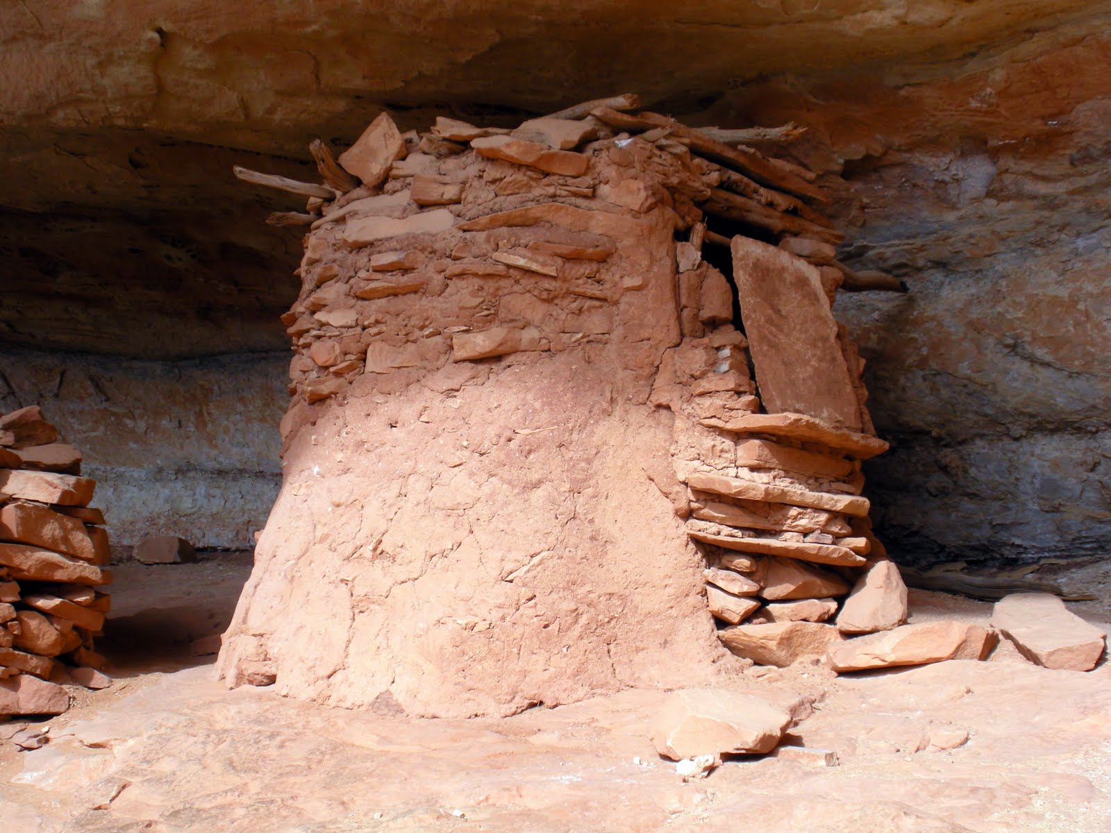
The highlight of the trip was coming up close and personal with the ruins of the Ancient Ones near the exit of Owl Creek Canyon. It is difficult to describe the surreal experience of standing next to ancient history, out there in the open for the world to see, in the middle of nowhere where almost no one ventures to see it.


They were here

Ruins

Ruins

A nearly intact Kiva

Ruins

We made it out of the canyon just before the worst of the storm hit. A cup of coffee at every gas station along the way home helped warm me up. Another Thanksgiving to be thankful for.


Leaving the canyons

The group