I met up with Stephen and Jared on Thursday morning for another great adventure in Stephen's quest to climb the highest peaks in the United States. This year's plan was to climb Humphreys Peak, the highest point in Arizona, with an elevation of 12,637 feet above sea level. Humphreys Peak is part the San Francisco Peaks, a group of extinct volcanic mountains located near Flagstaff, Arizona. We made the two hour drive from Phoenix to Flagstaff and walked around town for a bit before checking in for the night. The downtown area, while small in size, was very lively and filled with restaurants, bars and shops.
 |
| San Francisco Peaks near Flagstaff, AZ |
We decided to hike Humphreys Peak on Friday morning, hoping to avoid the stormy monsoon weather that was in the forecast for the entire trip. Everyone agreed to an early morning start, and we were at the trail head near Arizona Snowbowl at 5am. We started hiking in the dark, but the trail was easy to follow and it gained elevation gradually from the open field where we began. As daylight arrived, we were treated to blue skies and beautiful views of the surrounding forests.
 |
| Stephen and Jared on the trail to Humphreys Peak |
 |
| An early start to beat the storms |
|
|
|
Around 3 miles into the hike, the trail became noticeably steeper, climbing quickly above treeline and reaching the saddle below Humphreys Peak. The views of the surrounding summits and expansive forests below were spectacular. The weather was clear and cool, a bit of a surprise given the gloomy forecast.
 |
| Stephen hiking towards the saddle |
 |
| View from the saddle |
 |
| Jared and Stephen at the saddle |
We made a navigational mistake at the saddle and took the Weatherford Trail away from Humphreys Peak. Eventually, we realized our error and made our way back to the saddle. The sign indicating the correct trail to the summit was turned around to face downhill traffic - not very useful for hikers arriving from below.
 |
| Wrong trail but great views |
The last mile to the summit was very rocky, and the trail was occasionally difficult to find and follow. It was slow going walking over the rocks, but everyone was enjoying themselves as the weather was perfect and the views were amazing. The summit finally came into view after a few false summits, and we arrived at the peak around 8am. We completed the entire hike at 11am, just as the first thunderstorms of the day rolled through. Thai food, beers (for me) and sweet treats were the rewards after a great day on the mountain.
 |
| Stephen making his way to the summit of Humphreys Peak |
 |
| Humphreys Peak |
 |
| At the summit of Humphreys Peak |
 |
| Jared at the summit of Humphreys Peak |
On Saturday, we headed towards Winslow, AZ to see the world-famous Meteor Crater. I visited the crater with my grandparents when I was very young, and I was excited to see a place that I remembered well from my childhood. The crater was formed when a meteor impacted the area about 50,000 years ago, blasting a hole 1 mile in diameter and over 500 feet deep. Fortunately, it was interesting enough to offset the $18 admission price.
 |
| Meteor Crater |
On our way back to Flagstaff, we stopped at
Walnut Canyon National Monument. The monument was established in 1915 to protect the ancient cliff dwellings that were built by the Sinagua people between 1100 and 1250 AD. We hiked the Island Trail, descending 185 feet into the canyon and along a rim containing several preserved cliff dwellings. Aside from the interesting dwellings, the quiet solitude and beautiful flowers made Walnut Canyon a stunning place that I could have enjoyed for an entire day.
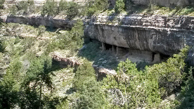 |
| Cliff dwellings at Walnut Canyon National Monument |
 |
| Island Trail at Walnut Canyon National Monument |
 |
| Walnut Canyon National Monument |
 |
| Walnut Canyon National Monument |
 |
| Flowers along the Island Trail at Walnut Canyon National Monument |
The final stop of our busy Saturday was
Sunset Crater Volcano National Monument, a dormant cinder cone located north of Flagstaff, AZ. The volcano erupted around the year 1085 AD, spewing ash and lava flows across 800 square miles and disrupting the lives of the Sinagua people living in the area. Like Walnut Canyon, this monument was peaceful and beautiful, with several hiking trails around the lava flows and cinder cones. We hiked the Lenox Crater trail, a 1 mile trail that offered some great views of the San Francisco Peaks, Sunset Crater, and the Bonito lava flow.
 |
| Lava flow in Sunset Crater Volcano National Monument |
 |
| View of the San Francisco Peaks from Lenox Crater Trail |
 |
| Flowers along the Lenox Crater Trail |
 |
| Sunset Crater |
I spent Sunday walking around the Northern Arizona University Campus and visiting the exceptional Museum of Northern Arizona. To finish a great trip, I enjoyed some delicious beers at Lumberyard Brewing Company and Mother Road Brewing Company, and had a fantastic dinner at
Red Curry Vegan Kitchen. I fell in love with Flagstaff and hope to return again soon. Thanks to Stephen and Jared for planning a great trip!


