Winter has begun to loosen it's grip on northern Utah. The daylight hours are noticeably longer and the snow in the lower elevations is gone, washed away by recent rain storms. It hasn't been a harsh winter in Salt Lake City, especially compared to the snowed-in East Coast, but I am ready for the season to be over. Roger and I decided to spend the Presidents' Day holiday weekend in Death Valley, California to enjoy some sun and warmth, and to jump start the Spring fever that inevitably sets in this time of year.
 |
An inappropriate but welcome sight in Death Valley
|
After spending the night at Hunter and Col's house in St. George, Roger and I drove the final four hours to Death Valley on Thursday morning. One of the most exciting aspects of entering Death Valley, aside from the stunning scenery, is watching the outside temperature rise as you descend below sea level. We made a quick stop at photogenic Zabriskie Point and then on to Furnace Creek Campground where we had a site reserved for two nights of mild desert camping.
 |
| Zabriskie Point |
 |
Site 107 at Furnace Creek - one of the nicer sites
|
After setting up camp, we decided to head down to Badwater Basin to see a few of the more popular sites in Death Valley and to visit the lowest point in North America. We arrived at Badwater Basin just in time to join ranger led walk out to the salt flats and learned a bit about the unique geology of the area. The highlight was walking farther out on to the salt pan than most people venture to view some of the salt polygons created by evaporation and salt accumulation in the basin.
 |
| Badwater Basin salt polygons |
 |
Badwater Basin salt polygons
|
We made a quick stop at nearby Devil's Golf Course to walk across a different part of Badwater Basin. This area was filled salt boulders covered with extremely sharp salt crystals, making walking a difficult and potentially a painful experience if one made a misstep. The quiet solitude and beautifully harsh scenery of this area is what makes Death Valley such a wonderful place to explore.
 |
| Salt crystals at Devil's Golf Course |
Heading north, we drove through Artist's Drive to view some of the vividly colored cliffs overlooking Badwater Basin. The most photographed area of this drive is a hillside called Artist's Palette that contains a mix of many unusual colors, including pink, white, and blue.
 |
| Artist's Drive |
 |
| Artist's Palette |
As the sun began to set, we headed to the popular Golden Canyon trailhead and walked through the canyon for a few miles before ending up below Zabriskie Point. The canyon itself was nice, but the highlight was walking up and out of the canyon on one of the many side trails to get views of the surrounding cliffs.
 |
| Golden Canyon at sunset |
 |
| Golden Canyon at sunset |
 |
| Sunset from Golden Canyon |
 |
| Full moon over Death Valley |
On Friday morning, Roger and I headed to the western side of Death Valley to experience some of the less visited areas of the park. Our first stop was a place called Darwin Canyon, just west of Panamint Springs, that contains a desert oasis of trees, flowers, and waterfalls. The sharp contrast of water and greenery to the surrounding barren rock is dramatic, and the waterfalls themselves were spectacular. This would be an amazing place to visit on a scorching summer day in Death Valley.
 |
| Darwin Canyon |
 |
| Lower Darwin Falls |
 |
| Upper Darwin Falls |
Following Darwin Canyon, we returned to Panamint Valley and took a bumpy dirt road off the main highway to reach the access point for Panamint Sand Dunes. After a several mile trek across the open desert to reach dunes that never seemed to get any closer, we were rewarded with graceful, shifting mountains of pure white sand and what felt like an entire valley to ourselves. The sun was hot and the dunes were exceptionally fun to explore, making for a perfect summer day in mid February.
 |
| Hiking to Panamint Sand Dunes |
 |
| Panamint Sand Dunes |
 |
| Panamint Sand Dunes |
 |
| Panamint Sand Dunes |
 |
| Sunset in Panamint Valley |
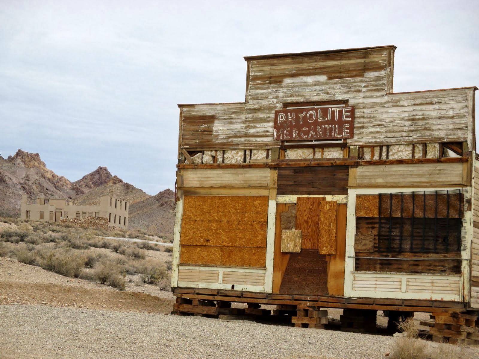
Hunter and Col joined us in Death Valley on Friday evening, and on Saturday morning we packed up camp and headed to the town of Beatty, NV to fill up on cheaper gas and begin our next adventure. Our first stop was the ghost town of Rhyolite, NV, a former gold rush town that peaked in 1907, and the nearby Bullfrog-Rhyolite cemetery. Later, we made the scenic drive through Titus Canyon before returning back into Death Valley.
 |
| Rhyolite Ghost Town |
 |
| Rhyolite Ghost Town bank |
 |
| Cemetery plaque |
 |
| Bullfrog Rhyolite Cemetery |
 |
| Titus Canyon Drive |
 |
| Titus Canyon |
 |
| Leadfield Ghost Town mine |
 |
| Titus Canyon Drive |
After returning to the main valley, we headed north and made a quick stop at Ubehebe Crater before continuing on the dirt road toward Racetrack Playa. The road to the Racetrack was fairly well maintained and I was surprised by the number of cars we passed along the way. Despite the somewhat remote location and the long dirt road, it was obvious that the Racetrack has become a popular destination. We stopped at the north end of the playa to climb around the Grandstand and then drove south for a couple of miles beyond the playa to the primitive Homestake Dry Camp. Several good camping spots can be found at Homestake and we enjoyed a peaceful evening under the stars until a group of noisy campers arrived to break the stillness.
 |
| Ubehebe Crater |
 |
| Along the road to Racetrack Playa |
 |
| Teakettle Junction |
 |
| The Grandstand on the Racetrack Playa |
 |
| Homestake Dry Camp |
On Sunday morning, Roger and I woke up before sunrise and headed back to the Racetrack Playa to see the mysterious "sailing" stones, the main attraction that brings everyone to the playa. These stones are thought to move when a combination of water, ice, and wind make the surface of the playa slick enough and the rocks buoyant enough to leave mysterious trails in the mud. Despite seeing pictures of the sailing stones beforehand, witnessing them in person at sunrise was a surreal experience. We had the entire playa to ourselves, a far different experience than if we had visited the playa during the middle of the day.
 |
| Sailing stones on Racetrack Playa |
 |
| Sailing stones on Racetrack Playa |
 |
| Sailing stones on Racetrack Playa |
 |
| Sailing stones on Racetrack Playa |
 |
| Sailing stones on Racetrack Playa |
Roger and I attempted to access Saline Valley from the Racetrack, driving along the severely bumpy and exposed Lippincott Road for two miles, until it became clear that our vehicle was not suitable for the drive without risking damage or flat tires. The hot springs of Saline Valley will have to wait for another visit. We turned around and headed back to Furnace Creek, experiencing a flat tire along the way, and had a nice lunch break in the warm sun before returning to St. George on Sunday night. I look forward to the day that the summertime temperatures we experienced in Death Valley return to Salt Lake.
 |
| A perfect day in Death Valley |