I returned to Utah on Wednesday after a week of visiting family in Massachusetts for the Christmas holiday. With a dry, mild forecast through New Year, Roger suggested that we head south to Moab for some hiking in the quiet off-seaon. We left Salt Lake on Thursday morning and arrived in Moab during the early afternoon, with a few hours of daylight remaining to do some exploring. We decided to check out Arches National Park, since it involved the least amount of driving from downtown Moab. A storm moved through southern Utah just after Christmas, leaving a blanket of white on the famous redrock. A few days of sunshine melted the snow in warmer spots, leaving a patchwork of red and white throughout Arches National Park. We arrived at the Delicate Arch trail head for a quick hike to one of Utah's most famous landmarks. For a midwinter day, there were a lot of people on the trail!
 |
| Hiking to Delicate Arch |
 |
| Patches of snow along the trail to Delicate Arch |
 |
| Hiking to Delicate Arch |
 |
| Delicate Arch |
 |
| Enjoying the views around Delicate Arch |
It was late in the afternoon as we finished our hike to Delicate Arch. We decided to make our way over to Skyline Arch to watch the last few minutes of daylight illuminate the redrock. Sunset is always an amazing time to be in Arches National Park!
 |
| Sunset lighting in Arches National Park |
 |
| Skyline Arch |
We spent Friday exploring the Island in the Sky District of Canyonlands National Park. Easily the most accessible district from Moab, Island in the Sky offers stunning views of the canyons surrounding the Green and Colorado Rivers. Because Island in the Sky is on top of a mesa, most of the hiking trails to various overlooks are either short and flat, or very lengthy, with significant elevation change as they descend down to the White Rim. We opted for several of the shorter trails on the top of the mesa, none of which I had ever done before.
 |
| Sleepy Moab in the winter |
 |
| The Monitor and the Merrimac on the way to Canyonlands |
 |
| Green River Overlook |
 |
| Green River Overlook |
 |
| Green River Overlook |
Our first hike of the day was a 1.6 mile out and back trail to a couple of overlooks above Upheaval Dome. Either an ancient meteorite impact crater or an uplifted salt dome, Upheaval Crater is one of the more interesting geological features in Canyonlands. Views of the surrounding canyons, and several pockets of water-filled potholes along the trail, made for a scenic hike.
 |
| Trail to Upheaval Dome Overlooks |
 |
| Water-filled potholes |
 |
| Upheaval Dome Crater |
 |
| Views above Upheaval Dome |
Next, we hiked the short trail to the top of Whale Rock for expansive views of the surrounding canyons and mesa. After a snack and beer break, we hiked to a couple of granaries tucked below a ridge, and then to the top of Aztec Butte.
 |
| Hiking refreshments |
 |
| Granaries |
 |
| Granaries |
 |
| Hiking up Aztec Butte |
 |
| At the top of Aztec Butte |
Our next hike was the slightly longer 3.4 mile out and back trail to Murphy Point, which passed through an expansive grassy meadow on the way to a scenic overlook above the Green River.
 |
| Murphy Point |
 |
| View from Murphy Point |
We had just enough time before sunset to hike the White Rim Overlook trail, a short walk leading to one of the best views in Island in the Sky. The late afternoon sun lit up the La Sal Mountains in the distance, as the canyons below us glowed brilliant orange. It was a spectacular way to end the day.
 |
| White Rim Overlook |
 |
| Canyons of the Colorado from the White Rim Overlook |
 |
| La Sal Mountains from White Rim Overlook |
 |
| White Rim Overlook |
On Saturday, we made a day trip over to Hovenweep National Monument in far southeastern Utah, the site of several Ancestral Puebloan villages famous for their unique tower structures. Before arriving in Hovenweep, we stopped in the quiet town of Bluff to visit the Bluff Fort Historic Site, a restored settlement commemorating the difficult journey Mormon pioneers made to establish the town via the treacherous Hole-in-the-Rock trail.
 |
| Bluff Fort Historic Site |
 |
| Roger celebrating his pioneer roots |
Although Hovenweep National Monument contains the ruins of several Ancestral Puebloan villages, the most famous and accessible site is located along the canyon rim at the visitor center. Known as the Square Tower Group, the village was home to about 500 people, and includes the famous Square Tower Ruin. Despite being well off the beaten path, Hovenweep was well worth the visit!
 |
| Tower Point Ruin |
 |
| Hovenweep Castle |
 |
| Square Tower |
 |
| Hovenweep Castle |
 |
| Twin Towers ruin |
 |
| Roger at Hovenweep Castle |
Moab was quiet on Sunday as people on vacation headed home from their Christmas break. The weather was cooler and cloudier, but we still wanted to hike. We decided to explore Grandstaff Canyon (formerly known as Negro Bill Canyon) just outside of Moab. It turned out to be a great hike through a gorgeous canyon. Along the way to Morning Glory Bridge, we passed through cold, sheltered regions of the canyon where snow and ice crystals decorated rocks and tree branches. We were were happy that we had our microspikes because most of the trail was packed snow and ice.
 |
| Hiking in Grandstaff Canyon |
 |
| Grandstaff Canyon |
 |
| Ice crystals in Grandstaff Canyon |
 |
| Morning Glory Bridge |
We took a quiet drive down Potash Road as the sun began set on 2017. Everything seemed so much quieter than it was on Thursday when we first arrived. The dim, pink light of sunset filtered through some breaks in the clouds, while the nearly full moon rose over the canyon. The Colorado River flowed swiftly and silently below the road. Moab was settling back into winter silence. Later that night, from a balcony above Main Street, we welcomed the new year as a few scattered fireworks lit up the sky.
 |
| Potash Road on New Year's Eve |
 |
| Petroglyphs along Potash Road |
 |
| Silence returns to Moab on New Year's Eve |
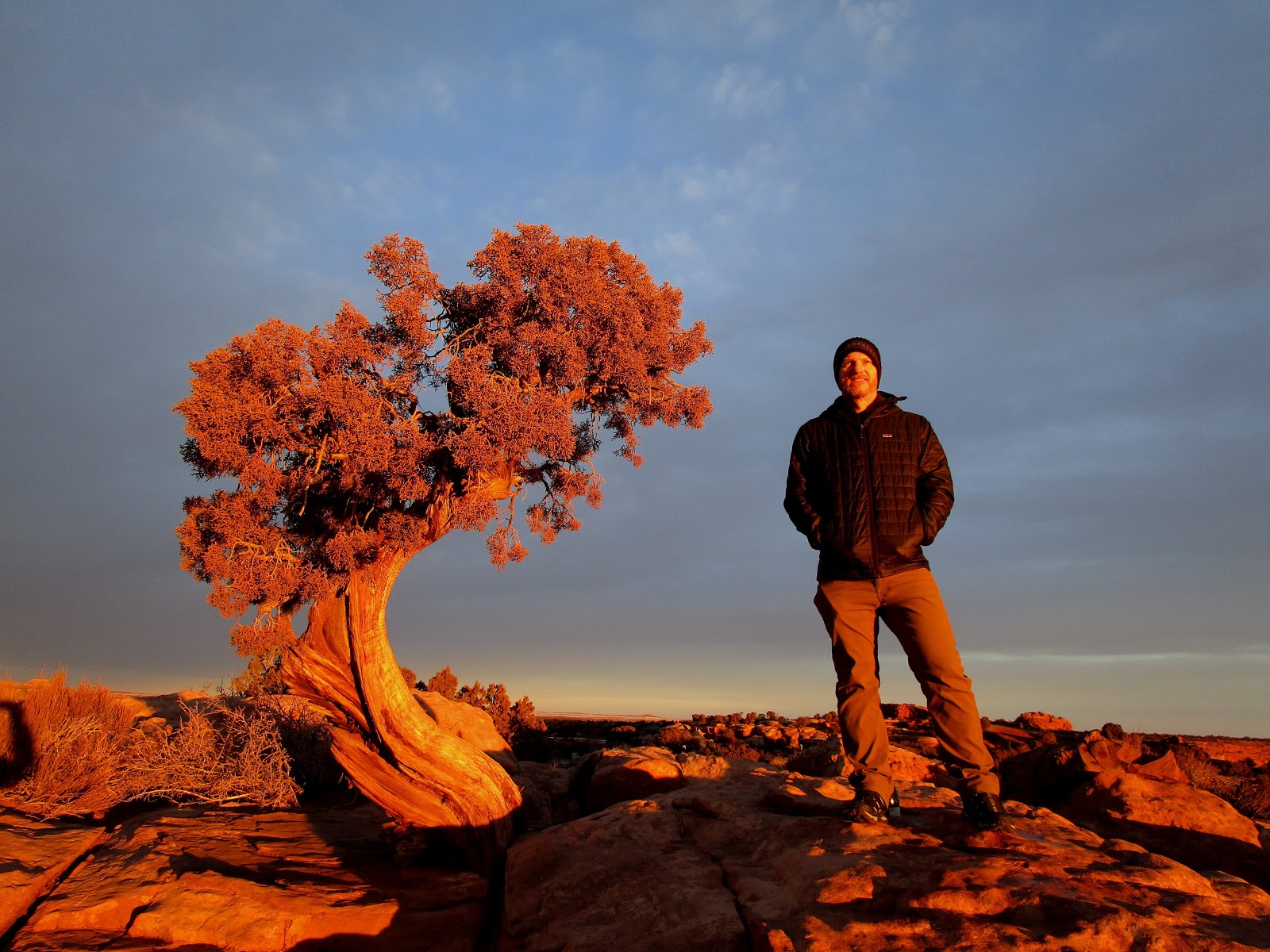
We awoke early on New Year's Day and headed to Dead Horse Point State Park to watch the sun rise. The sky was filled with clouds, but the eastern horizon was clear. Soon after we arrived, the first sunrise of the new year greeted us, lighting up the entire mesa with a beautiful orange glow. It was a spectacular way to welcome 2018!
 |
| First sunrise of 2018 |
 |
| Sunrise at Dead Horse Point |
 |
| Sunrise at Dead Horse Point State Park |
 |
| Welcome 2018! |