Showing posts with label Uinta Mountains. Show all posts

Monday, January 7, 2013

Uinta Mountains, Utah - Snowshoe and Yurt

I spent the past weekend in the Uinta Mountains of northeast Utah enjoying clear skies and sunshine above the dreary valley inversion that has plagued Salt Lake City for the past several days.  Jim invited me to join a group of people that had reserved a Bear River Outdoor Recreation Alliance yurt on the north slope of the Uintas, about 30 miles from Evanston, WY.

Lily Lake Yurt

New friend Julie, Jim, and I headed to the trail head near Bear River Lodge Saturday morning and began the 3 mile snowshoe to the yurt.  We were joined later in the day by new friend Roger.  The first couple miles of the trail were closed to snowmobiles and the snow was so packed from other  snowshoers and cross country skiers that it was almost unnecessary to use snowshoes.  The last mile of the trail toward Lily Lake was open to snowmobiles and was very packed as well.

Jim and Julie on Sage Draw Trail

Julie on Sage Draw Trail

 Sage Draw Trail on the way to Lily Lake

Snowshoeing with Jake

It took less than two hours to reach the yurt.  The Lily Lake Yurt was well stocked with firewood and propane and the structure itself was clean and very well maintained.  The Lily Lake Yurt is one of five yurts in the Lily Lake Yurt System maintained by the Bear River Outdoor Recreation Alliance.  There was a wood stove to keep the yurt warm, a table and basic cooking equipment, and six bunk beds with sleeping pads.

Wood stove inside the yurt

Sleeping bunks

After Roger joined us, we spent time walking around Lily Lake and enjoying some good food and torturous card games.  Later that night we took advantage of the clear, dark skies for some fantastic star gazing.  It was a great weekend getaway with awesome new friends.

Roger was very excited to be at the yurt

View from Lily Lake

Jim loved converting snow to water


Monday, September 24, 2012

Uinta Mountains, Utah - Amethyst Basin - Backpacking

This past weekend I headed up to the Uinta Mountains in northeastern Utah for a quick overnight bakpacking trip with Katy, John, Keith, and Melissa (and Stoli and Tonic!).  We decided to hike in Amethyst Basin because it's just a two hour drive from Salt Lake City to the trailhead at Christmas Meadows and we only had the two day weekend.  I did the hike to Amethyst Lake several years ago and enjoyed it very much so I was excited to spend a little more time hiking in the area and spending the night camping in the cool autumn air.

At the trailhead with John, Katy, Melissa, and Keith

We arrived at the trailhead early Saturday morning after a beautiful drive along the Mirror Lake Highway.  The aspen trees were brilliant gold and contrasted against the green pine trees and random patches of red and orange foliage.

Starting the hike to Amethyst Lake with John

Brilliant aspen foliage

As we made our way into Amethyst Basin we passed several waterfalls and walked through alpine meadows.  The scenery, foliage, and cool air were definite reminders that autumn has arrived in Utah.

Waterfall along the way to Amethyst Lake

Keith, Melissa, Stoli, and Tonic

 Keith, Melissa, Stoli, and Tonic in Amethyst Basin

After hiking for several miles we reached our destination and camping spot for the night - Ostler Lake.  This hike seemed a lot longer and a lot more difficult than I remember, probably because of the heavy backpack.  We found a great camping spot not too far from Ostler Lake and spent the evening enjoying good food, drinks, a nice campfire, and even a little fishing (not me, of course!).  The fish weren't biting, but Katy and John still had a great time.

Keith crossing a small stream

Ostler Lake

 Uinta Beer in the Uinta Mountains

John scaring all the fish away

Ostler Lake

Katy catching all the fish

On Sunday morning we cleaned up camp, packed up, and headed up to Amethyst Lake.  It was only about a mile away from where we camped and the scenery was spectacular.  We spent some time at the lake before heading back down the trail to finish the trip.

Melissa

Along the trail to Amethyst Lake

John and Katy

 Amethyst Lake

Amethyst Lake

Along the trail to Amethyst Lake

John at Amethyst Lake

 Ostler Peak

Tuesday, September 27, 2011

Uinta Mountains, Utah - Backpacking

With the cooler weather rapidly approaching, a bunch of us decided to set out for a weekend in the Uinta Mountains of northeastern Utah before we'd need to strap on snowshoes to enjoy the scenery.  With the exception of the King's Peak trip last summer, most of my time in the Uintas seems to be spent during the winter months doing some snowshoeing to some of the hundreds of lakes in the area.  The Uintas in the summer are even more spectacular and the scenery is a sharp contrast to the redrock deserts of southern Utah.

Bald Mountain and Reid's Peak

Robert, Ryan, Keith, Melissa, Joe, and I, along with a few dogs, set out from Salt Lake early Saturday morning for the two hour drive to the Uinta Mountains via Kamas, UT.  We decided to do any easy backpacking trip that focused mainly on the camping and less on the hiking so that we could relax and enjoy some good food and drinks in the beautiful wilderness.  If someone saw us in the parking lot with of all of gear and packs, they would have probably assumed we were backpacking for a week.  Melissa thought the hike would only be about a mile, but it was quite a bit longer than that.  We probably would have taken a few less luxuries had we known we'd be hiking for several miles.

Melissa, Keith, Tonic, and Stoli

Joe, Robert, and Ryan

Our destination was Cuberant Lake where we planned to camp Saturday night before hiking back out on Sunday.  The hike passed through a few beautiful meadows that are typical of the Uintas, and a few smaller lakes before finally climbing up to Cuberant Lake.

 Meadow

 Snack break along the trail

Smaller lake just before climbing up to Cuberant Lake

We found a great campsite near the lake and set up camp for the night.  The sunset created some beautiful colors and reflections on the calm lake, and as the temperatures dropped we made a great fire to keep us warm for the evening.  After hauling in what felt like tons of food, beer, and wine, we were finally able to relax and enjoy a great evening of eating and drinking.  

This is more Dakota's style.  Hiking is overrated.

 Keith enjoying his toasted "ghost peep"

Cuberant Lake at sunset

Cuberant Lake at sunset

Enjoying the warm fire from a safe distance

It was a frosty night in the Uintas since we were at an elevation of over 10,000 feet.  The stars were beautiful with very little light pollution, so I stayed up for a quite a while in my tent enjoying the night sky.  It was difficult to get out of my sleeping bag the next morning; I'm not used to the cold so early in the season.

Joe filtering water in the morning

Ryan and Dakota

Cuberant Lake in the morning

After spending Sunday morning enjoying the lake and the warm sunshine, we packed our gear and headed back down to the trailhead.  The weather was absolutely perfect the entire weekend and I was fortunate enough to spend it outdoors with a very fun group of people (and dogs!) in one of the prettiest places in Utah.

Keith, Melissa, Robert, Ryan, me, and Joe

Monday, August 16, 2010

Kings Peak, Utah - Backpacking

I finally made it to the highest point in Utah - Kings Peak at 13,528 feet. Located in the High Uinta mountain range of northeastern Utah, this peak has always been rather elusive due to it's isolation, the very short season between snowmelt and snowfall, and the constant risk of lightning during the month or two of possible access. Robert put together a great group of hikers and we lucked out with absolutely perfect mountain weather for the entire weekend. Most people will do this hike as a two night, three day trip. We decided to go for an overnighter due to limited time.


Our group at the trail head

We left Salt Lake early Saturday morning and got to the trail head about 9am. I've never seen such a full parking area at a trail head before - obviously a very popular hike! We started out on the trail with our goal for the day being the area just below Anderson Pass, 10 miles from the trail head. The traditional route to Kings Peak follows the trail up and over Gunsight Pass, into Painter Basin, and then over to the peak. Climbing the very steep and rocky chute to Anderson Pass cuts out a few miles, and that was our plan due to the short nature of our trip.


Backpacking toward Anderson Pass

Hmm another alpine backpacking trip ... missing the desert...

Kings Peak in the distance with Anderson Pass just in front of it

Kings Peak and Anderson Pass - our shortcut to the peak

We found a good place to camp for the night just below Anderson Pass and quickly set up our tents before the sun set. Thankfully there was no lightning - our campsite was in the middle of an open basin. We enjoyed a beautiful sunset, had a great dinner complete with wine and mostly freeze-dried backpacker meals, and chatted well into the evening. It's amazing how cold it can get at night in the Uinta Moutains - even in the middle of August!


Setting up camp

My new tent

Keith and Ryan relax by our little fire

Dinner time

Sunset at our campsite

I was very nervous about the route up Anderson Pass - it seemed very steep and a little scary. Fortunately it wasn't quite as bad as it looked and everyone made it to the top of the pass in one piece. It was decided by several people, including myself, that we would not be going down the same way. We figured the traditional route wouldn't be much longer and it would certainly be less scary.


Looking back while climbing Anderson Pass

The view from the top of Anderson Pass - we camped in the basin below

I'm thrilled to be off Anderson Pass chute

Melissa, Keith, and Robert make their way up Anderson Pass chute

It was still quite a hike from the top of Anderson Pass to the summit of Kings Peak. After a few false summits and lots boulder hopping, we finally made it to the top of Utah. The views were unbelievable!


Robert on the way to the summit

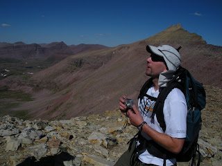
Keith way above tree-line

Almost to the peak!

At the summit of Kings Peak

Keith at the summit of Kings Peak

We made a little mistake on our return trip using the traditional route. Somehow we missed the turnoff and continued well into Painter Basin before heading back toward Gunsight Pass. We ended up logging over 20 miles the second day and while the trip was absolutely amazing, we were all very happy to see the end of the trail as the sun set on Sunday night.


Robert playing in last season's snow

Very tired - still several miles to go