After spending a week in Massachusetts visiting family for the Christmas holiday, I headed to Phoenix, Arizona with Roger for what we hoped was going to be a warm escape from the winter. We left Salt Lake in the midst of a cold snap and wind storm, but we knew the arctic air was following us all the way to Arizona. Last minute repacking swapped shorts and t-shirts for thermal shirts and a heavy duty tent. It wasn't the forecast we had hoped for, but we were still going to ring in the new year with a fun adventure.
 |
| View of the Superstition Mountains from camp |
Our plan was to camp at
Lost Dutchman State Park for three nights to hike in the Superstition Mountains, followed by two nights in a hotel so we could rent bikes and do some rides around the Phoenix area. We landed in Phoenix on Tuesday afternoon and took care of some food and firewood shopping before heading to Lost Dutchman State Park before sunset. We knew the storm was coming, but the evening was pleasant and we spent some time walking around and taking pictures of the gorgeous desert scenery.
 |
| Setting up the heavy duty tent |
 |
| Desert sunset at Lost Dutchman State Park |
 |
Desert sunset at Lost Dutchman State Park
|
The weather wasn't as bad as I was expecting on Wednesday morning, but the storm clouds were quickly rolling in from the south. We made nice breakfast, cleaned up, and hunkered down in the tent as the wind gusts increased and the first wave of rain moved in.
 |
Storm approaching the Superstition Mountains
|
After a couple of hours, the wind subsided and the heavy rain became more showery. We decided to hike around the trails at Lost Dutchman so we could be close to camp if the weather turned nasty. It wasn't the nicest day for hiking, but it was fun to walk around the desert landscape and plants in weather that seemed more appropriate for the Pacific Northwest.
 |
| Cactus wren during the storm |
 |
| Stormy Superstition Mountains |
 |
| Stormy Superstition Mountains |
 |
| Siphon Draw Trail |
 |
| Cholla cactus friends |
 |
Roger enjoying the stormy views
|
After a full afternoon of hiking, we returned to camp hoping to make dinner and start a nice fire for New Year's Eve. The rain began to pick up so we decided to return to the tent and wait for it to pass. The rain continued to fall for several hours and by 11 pm, I was beginning to worry that New Year's Eve was going to be a total washout. The sound of raindrops finally began to subside just before midnight. I emerged from the tent to find the rain had changed to snow and was coating the desert in an unexpected blanket of white. We welcomed the new year at midnight with a "miracle" fire that I managed to start and a traditional spray of champagne in the middle of an Arizona snowstorm.
 |
| A rare Arizona snowstorm |
 |
| Snow on New Year's Eve |
 |
| Welcome 2015! |
We awoke on New Year's Day to a desert landscape transformed into a winter wonderland. The sun was out and so were the locals, taking lots of pictures of the snow covered Superstition Mountains. After making a frosty breakfast, we headed to the Peralta trail head for some hiking in the Superstitions.
 |
| New Year's Day |
 |
| First sunrise of 2015 |
We had planed to hike the 13 mile Weavers Needle loop, including the popular Peralta Trail, but the trail beyond the saddle overlooking the Weavers Needle was buried in several inches of untrammeled snow. With no trail to follow, we headed back to the trail head and drove to the short and relatively easy Hieroglyphic Trail near Gold Canyon. After reaching the petroglyph area, we hiked a bit farther up the canyon to escape the crowds that were out for their New Year hikes. We returned to camp around sunset and enjoyed a nice fire as the skies cleared and the stars gave us a show.
 |
| Cacti and snow |
 |
| Peralta Trail |
 |
| Peralta Trail |
 |
| Saddle of the Peralta Trail with Weavers Needle |
 |
| Hieroglyphic Trail |
Despite the cold temperatures, we rented road bikes and checked into a hotel in Tempe for the remainder of the trip. On Friday, we did a 40 mile ride along the Bush Highway, paralleling the Salt River, and then up and over Usery Pass. Our ride on Saturday was a 55 mile loop around McDowell Mountain that included a stop at Fountain Hills. It was great to be on a bike in January and the sun made it feel warm, despite the cool temperatures.
 |
| Saguaro Lake |
 |
| Bush Highway |
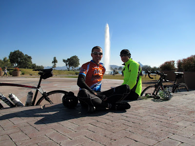 |
| Fountain Hills |
Before heading to the airport on Sunday to return to Salt Lake, we spent the afternoon at the
Desert Botanical Garden near Phoenix. The sun was out, the temperatures we back to normal, and the gardens were full of impressive desert plants. It was a great way to finish our Arizona adventure to welcome the new year.
 |
| Roger at the Desert Botanical Garden |
 |
| Desert Botanical Garden |
 |
| Desert Botanical Garden |
 |
| Desert Botanical Garden |